You are hereForums / The Knapsack Project / XC Track Naming
XC Track Naming

We are looking for ideas for naming the XC tracks.
Topics for naming are Historical to the site, Tribute to Gary Payne and Whats in the Area.
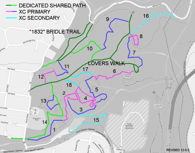
Attached is a map with sections numbered. It is a reference tool only. There are no starts and finish of sections set in stone. It contains the proposed loop in Blue and Magenta, and the Alternative XC in Cyan.
To get the Ball Rolling here are some of my ideas. (In bold are my favourites)
1+2a. Steam Express or Locamotive (Next to it is the old railway cutting)
2b+3. The Cave
4+5. Sawmill
8. Garys Loop
9. Paynes Track
10. Brookside Creek Quarry (As refered to in the Mitchells Pass Management Plan)
11. The Grande Staircase
13. Whistle Blower
14. Kick Off
15. Air One
16. Mitchells Decent or Whittons Decent
2012-5-2 Revised Map clearly showing the main dedicated sharded use trails as per the council Buiseness paper. Also added 2 more XC Alternate tracks as per the business paper.
- Login to post comments
- Bookmark & share
3 is the cave run
10 is the HoD (Hill of Death)
Also 10 should be closed to walkers IMO
Have you got 10 mixed up? 10 goes through the old historical quarry(over a hundred years old) and is one of the main shared trails for walkers. (Obviously there won't be any closures to walkers except for the downhill track). 11 is the large rock feature you may be referring to, some have called this a quarry but I don't believe it is. I'm pretty sure it isn't listed in the POM and its definetley not in the Mitchels pass Management plan.
Maybe you could call 1 or 15 Wascoe's Siding, as this was the original name of the stopping point at the watertank which was built for the steam trains coming up from the little zig zag and which was fed from Glenbrook Lagoon - I think the foundations are still beside the highway between Barnett St and the oval. Wascoe's station was actually at Blaxland, named after the pub which was once on the corner where Macca's now sits. The old pub chimney is in the carpark. Old Bathurst Rd and then Mitchell's Pass were the roads up from the plains and these used to pretty much meet at the pub before the railway got there.
I refer to the FT descent between 10 & 9. Pretty fast, pretty loose ... nice waterbars ... and there is a walkers only trail Closed off to riders looping around this section, which can be seen on the map
Descending sections where riders are at speed and it would be difficult to stop to avoid collisions should be recommended as riding only. Obviously the DH, however would see this FT section as a candidate.
I have revised the map in the opening post to reflect the business papers Dedicated shared use paths. I do not believe the dedicated shared use paths can be changed. Walkers are allowed on the XC tracks but they are not advetised as a shared path. If it is believed that section 10 is unsafe for walkers than it would be our resposibilty to make it safe by implementing safety measures. Such examples are track design, field of view and clear warnings. As for track naming, im not sure if Hill of Death would be an approprate track name for a shared path unless you consider this another safety device Personally I've never thought of section 10 as a danger to walkers and Ive crossed paths here several times.
Lach, I like Wascoe's Siding. Very clever.
As stated elsewhere, we wont be needing alot of names as this is just for signposting and mapping. There can be alot of names for other small bits and pieces known by the locals and regulars but they wont need to be published. Below is a map I created to show my idea for named track sections. Each track start and finish intersects with another track.
PS I dont believe the connector tracks 17 and 18 will need a name.
It would be absolutely amazing if number 10 could be made into a freeride style track, some nice jumps and flowy berms would be sweet! If there is cross country and downhill tracks here, freeride would be a perfect addition to this trail network.
Number 10 is currently a designated shared path. As for the freeride style track. I was thinking something like this could be done up the top of 11.
Bring it
Also, what will be happening with the track mitchells/whittons decent? Ive been told 'stringline' will be made into the downhill track in this area, but the other track (mitchells/whittons decent) also has alot of potential, very rocky, but could be made into something great!
That's a walking track. Hopefully it will be repaired too.