You are hereForums / The Knapsack Project / Update Knapsack DH tracks
Update Knapsack DH tracks

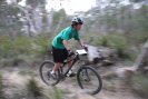
Brian H and I went for a wander down the mountain today in ana attempt to find a new alignment based on the original downhill tracks that currently exist on the mountain.
The proposal we put forward which included a new section of track seems to be a bit of a tough one for the council so they asked for another option based around some of the existing tracks.
So armed with the trusty Garmin device we delved into the potential of what could be created down the hill based around what was there to start with.
We need to do a few tweaks here and there but it may eveolve onto something half decent that takes in a bit of the exisitng established tracks whilst avoiding areas that are highly erosive or that would prove to be unmanagable or unsustainable for the long term.
The files have been downloaded and i have sent them up to Mark aka Moggio for the transfer to google earth to see what they look like.
So at the moment this the snapshot of where we are at with Downhill, Cross country is also progressing but i am a b it grey on developments on that side so perhaps the boys will continue on with the posts, i am pretty sure they are finalising what can and can't be acheived with in the constraints of the requirements put forward by council taking into consideration the flora and fauna and the historical sites etc...
So all up a lot of positive things happening in Knapsack, time will tell.....
- Login to post comments
- Bookmark & share
I just sent an email to Staff following our meeting last Monday.
Subject to confirmation from Soren:
I believe in principal, the Main XC track is agreed and will be a loop.
As explanation of Loop versus Network. one of the stated aims of staff is to rationalise the trails available. Similarly, Riders' stated aim is to maximise the trail length as much as possible.
Therefore the trade off is that we need to close down as much of the "disused"or "ün-essential" tracks and connectors as possible as a direct trade to potential trail extensions and realignments to increase the current tracks flow and sustainability. There is almost a direct link between the amount of track we can close versus the amount of track we can obtain for realignment (subject to enviro + assessments)
So, the main loop we depicted in concept is fairly much agreed (80%) with some finesse-íng of direction of certain sections (section 14 in particular).
As you can see from Mark's BMORC report, we have included potential for additional "Outer Loops". At this stage we are seeking advice from Staff whether these loops/sections are in scope of what we need to provide for the Oct 2010 assessment report. Noting, there is an additional BMCC assessment report required with regards to the Mushroom tunnels, and we have similarly flagged the "sewerage to Raaf" loop as something we would like to keep. At this stage, our thinking is that we are best to ask now, even if we address it in more detail in a latter phase, as the priority is to make the existing tracks sustainable, and enjoyable.
With regards to the DH track
As per Kingy's post above, I suggest the more DHérs that provide input the better. However, we continue to advocate and support Staff findings as per the report issued 16Mar10. Any track in Knapsack will need substantial realignment, design and construction efforts, to develop sustainable, enjoyable tracks with a suitable ride length. So keep this in mind.
Notwithstanding, if by some chance we were granted the new alignment Kingy marked out, then I reckon it has the potential to be a fun track, with some great features, that can cater for multiple skill levels with lots of further potential should we be able to work in partnership with PCC as we have with BMCC.
Request:
Further trail building, riding of closed tracks.
It has been brought to our attention that riders continue to ride closed tracks and cut new lines, even in knapsack. as per a recent post and email by Tim. This has a direct impact to what we are doing with council, and limits our effectiveness.
Please keep an eye out for anybody doing this, and in a non-confrontational way, let them know what we are doing, and what they are doing may stuff us up Royally. Part of our self policing and rider code of conduct I guess.
I'll put something up in RB as well.
Some of this preliminary data for the possible alignment C line is up here
http://bmorc.com/node/16726
Hi Kingy and Moggio,
Looks like you guys have done some nice mapping again, is there still talk of cutting in a track lower to pop out near that railbridge or does it have to stop at the road, where it stops now? As I do recall an earlier map looking into that.
Also Al, can you let me know which areas are still being ridden and where people at still cutting in new lines etc.
Cheers, Gus
Hi Gus... yeah we are still floating ideasaround, I guess as many variations as possible that we can piece together based around what council allows. The more options and concepts we have the better.
There was the plan on an earlier alignment if we can come out in the appropriate position then take advantage of that drop some more in altitude and hook things up near the railbridge. The critical issue here is coming out at the right location which obviously depends on whether we would be able to cut a line to get there. That is being looked at by council at the moment whether that area of the hill has restraints on it.
In many ways council would like us to piece together as much of the existing bits of track and trail as possible only cutting new sections where really necessary. Every new bit requires a whole lot of assessments and time and effort to see whether they meet heritage and environmental requirments.
So its all tradeoffs... obviously if a suitable line could be found in this manner it would mean less work for building and also less time spent by council on assessments so the new track would be up and running much sooner. However we obviously want to get the best trail possible and also because if we have a really awesome legit trail it would stop other tracks being built serving councils purpose as well.
Paul and I will be out there either Firday or Saturday morning looking at a few more ideas he has.
This trade-off where the amount of new track needs to equal the amount of old track that we close is a poor outcome. This type of thinking creates a situation that rewards cutting new illegal tracks - which is crazy. The more illegal tracks that are cut, the greater the track length we might get when we formalise tracks within a particular area. The sub-text of this situation is that Council will not allow any new tracks in the mountains.
I appreciate that Council don't want the area riddled with tracks - but nor do most of the people who ride there. The DH track would only be visible to the riders on it. To all other users of the Reserve it would be virtually invisible.
The approach of Council staff appears to be more onerous and restrictive than the intentions of Councillors at the June Council meeting. Restricting where we cut a new track based on the sensitivity of the area is an an environmental requirement. Limiting the amount of new track to the amount of old track that is closed is not an environmental requirement.
Is there any way we can challenge this position?
I see what you mean re illegal tracks ... but really, its a one off trade.
Once established (and even now) there are Council expectations that riders (BMORC) are setting codes of conduct and self policing to eliminate illegal / unapproved (I prefer unapproved) trails, this includes poaching closed trails too.
I've just read the yellomundee PoM (re MTB) and there was a blurb in there about rehab / reveg, or reforestation (apologies I can recall exactly the wording) ... however, basically, they need areas were people aren't accessing the bush so that it can regen itself. I can very much appreciate what they are doing now, and can see the compromises.
Re Staff approach. I disagree. Council will (in most cases) rely on Staff expertise and leave the management to staff I don't think the June meeting changed any of this, they just let us back into Knapsack which had an established PoM.
To clarify ... New Trail extensions are not a given, all new trail will require an element of assessment (primarily archaeological, however, some enviro stuff as well). IMBA suggested the trade off between closing and opening trails and Soren was again open minded about this ... subject to assessment.
Soren has been very clear from the beginning of my involvement that rationalisation has always been a clear objective, we closed off unused track at OBR, prior to it all going pear shaped, and the PoM mentions trail closures at Knapsack. Pretty sure its all very consistent with other reserves as well.
I think we are following due process ... in a very open and practical way, with both sides very much compromising and or negotiating for key aspects important to them. quid pro quo ... like in any good relationship.
Gents I concur with Al's assesment and believe that we are not conceeding in our dealings with council we are infact co-operating in what is very much unchartered territory. We must remember not to be one eyed about our desire to win trails at the risk of losing our credentials as a model of sustainability, our way forward is to work closely with council staff ensuring that we meet the perceived enviromental outcomes that they put forward as sustainable and acceptable, to do any less would only hinder the cause. The council and the staff hold the environmental cards and we as players are only able to play the hand we are dealt, I for one feel that this whole process is progressing well and that in the not to distant future we are going to see a much more motivated position from councillors to promote and endorse mountain biking in the Blue mountains as a viable tourist attraction that has a revenue. What we do now at Knapsack is a case of baby steps, there is a lot at stake and I don't want to see any battle lines drawn over trail issues which are ultimately largely not ours to contest, council staff are working with in some very clear guidelines and as a group BMORC realises the importance of these and are supportive of the efforts being made by council staff to accomodate our unique requirements. Patience is something we will need to master for this project, in time we will win the day it will be worth the wait.
Neil I think your point that
"Restricting where we cut a new track based on the sensitivity of the area is an an environmental requirement. Limiting the amount of new track to the amount of old track that is closed is not an environmental requirement."
is really the most important points we will ever need to make. I think that is really the crux of the cookie, however I don't think we are in a position to stress that at the moment either by bargaining position where we are still quite weak (especially with proven evidence that we can present) or that council can freely see and use as a bonfide arguement for their internal procedures.
I think Knapsack will be the test case that we will be able to eventually create precedents, however I don't think this method of rehabing tracks to get new trails will become a precedent later on. I think it will show more the interest in riders actually caring about the environments they want to ride.
That sound you just heard was me pulling my head back in. Point taken.
always good to talk (type) these things over Dude, just in case we may be missing something ... and also get everybody on the same page, before we go talking to the general public etc
http://lp1.pinkbike.org/p4pb5759915/p4pb5759915.jpg
Some signage I found that we can use for the DH crossing of the FT