You are hereForums / The Knapsack Project / Photo Track Planning
Photo Track Planning
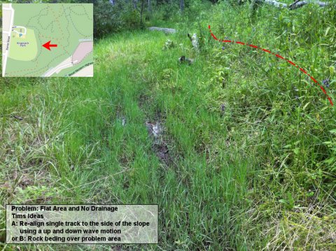
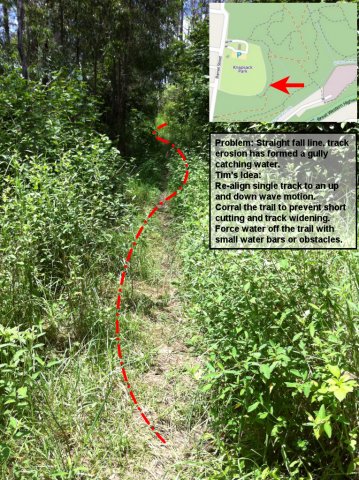
A month or 2 ago I took alot of photos from around Knapsack and then started fooling around with Paint. Thought I would post it up. Would something like this be helpful? As seen in the photos I have "Tims Ideas" as I dont have an IMBA guide to reference from.
- Login to post comments
- Bookmark & share
Tags


Yeah Tim we will will have to present stuff like that. I'd say before any build day we will have to scan the areas we want to work on, take pictures of what we want to do and mark them up as you show there.
So before the build day everyone will know exactly what needs to be done, have any approvals worked out, mapping etc and then can turn up with it all marked and ready.
So if you can do the computer stuff for this rather than me all the better!!!
Kingy has my IMBA Sweet Singletrack book, so you need to try and grab that of him. If you can liase directly with him, maybe pick it up on monday at the Springwood meeting? I think you would really enjoy a read of that.
Definitely a before and after survey ... pictorially highlighting the areas that need to be worked on ... we should also then put a priority list (not sure whether quick wins or more unsustainable gets the nod ?? what you peeps think ??)
I thought, given grant funding may be a little slow to flow .. that quick wins may provide more benefit ... uhmmm quickly ... but I also thought, we'd get disproportionately more volunteers early on so could use these for harder areas ... ??
Thats really good work Tim
I was thinking we start with the sections of track to get the loop in early, that way it would also give it the most time to bed in. Then Focus on fixing other sections, then followed by tweaking as required. Like Nick Bowman had said, a trail build is never finished until a year after it was opened.
Ah the memories, I remember when that part of the track was nice smooth firetrail. A few years later and look what it has turned into. A natural swoosh has started due to the blackberry and ten other types of weeds there plus a few fallen trees. Will be nice to clean up that area a little.
Also, that track will be moved slightly as the oval is going to be extended.
I too remember the firetrail I remember when I hadnt been there for over a year or 2 and when I came back i knew it was around but couldnt find it.
Yeah Tim I think as far as how things will go when we start on the XC is as you say, work on getting the loop sections in so it beds in and becomes a track that can be signposted and have a map. I think that will make things attractive for riders to want to then help on the less glamorous stuff like erosion and water retention.
Couldnt help myself
Ive made 2 more for sections that would be a good place to start.