You are hereForums / The Knapsack Project / Map recommendation as per 4/8/2010
Map recommendation as per 4/8/2010

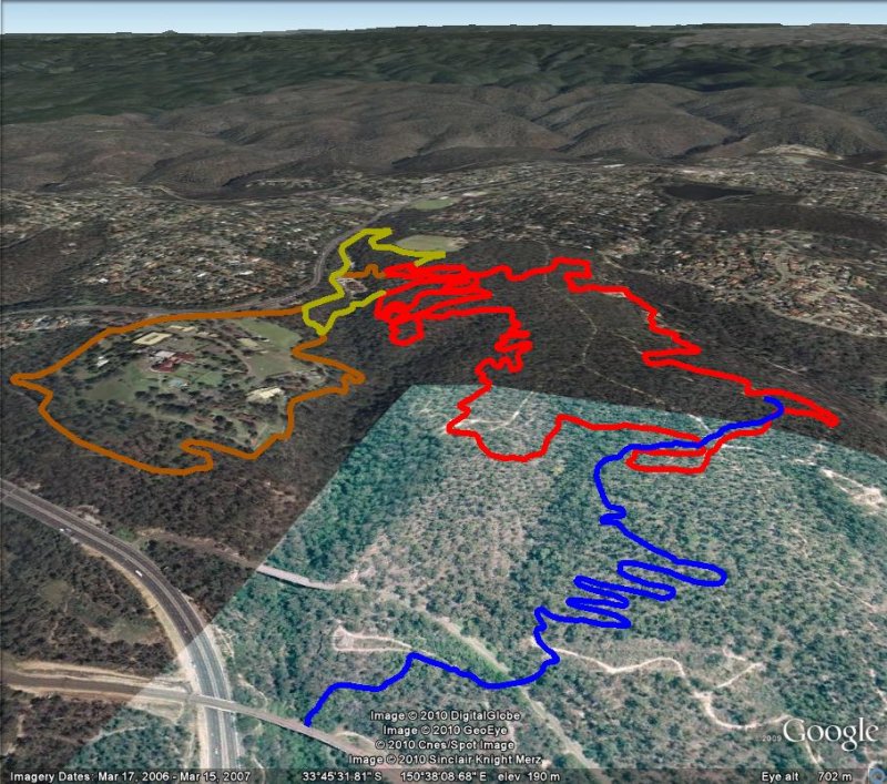
This is the preliminary map that has been created by rider input and lots of on the ground assessment. Some information behind the thinking...
1) We have a limited area to work in and likely limited amount of changes we can do so it is an attempt to best utilise what is there to get a maximum length that can be made entirely sustainable. Primary loop would be around 6.1km.
2) It is a primary loop with an attempt to use the area around the RAAF base for a secondary more technical loop.. whether the RAAF base track is even possible due to lots of zoning type restrictions is another question. RAAF base loop would be 2.8km, while existing loop around sewarge works would be 1.8km.
3) A plan to reroute the DH track in a way that doesn't waste altitude as quickly as the old "Stringline" DH track.
Lots of comments on the individual sections in the next post. Please read through.
We have no idea how council will react to this so this is being presented as a guide as what is possible and what riders would realistically like within the current restraints.
If anyone wants a gpx file of the different tracks to use in google earth please send me your email address and I will forward them.
Some people have mentioned the idea of a "network". Some points about this issue, networks are fine for large parks with lots of distance where each section of the network is a ride in itself of a few minutes. Knapsack is not a network is too short to network where these sections of "network" are maybe 100m long. Realistically the only area that has a matrix of connections is the area below "two logs" and above the gully. This area would be much better to maximise usage of what is there and see whether some new sections can be cut to take advantage of the nice terrain in this area.
The advantage of a loop is that the entire track can be "sweetened" up where every corner can be addressed and made to flow. Intersections don't allow for this. Its much like the difference between watching a movie on a commerical channel with constant interruptions to its flow rather than watching on a DVD.
Also council I think wants a loop. It will prevent new sections being cut illegally and can allow controlling the track so it is sustainable.
Comments more than welcome, in fact a necessity please!


- Login to post comments
- Bookmark & share
These numbers relate to the map posted above.
Just what seems to be the best use of what is existing and is a good ride. Also looking at just a few adjustments so reduce erosion, improve flow and extend length.
The likely shared use between points 5 and 21 means this section will have to stay technical and therefore slower which is probably what most riders want.
Some discussion on the maps
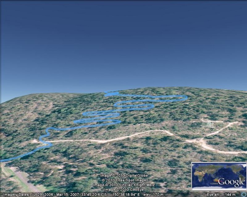
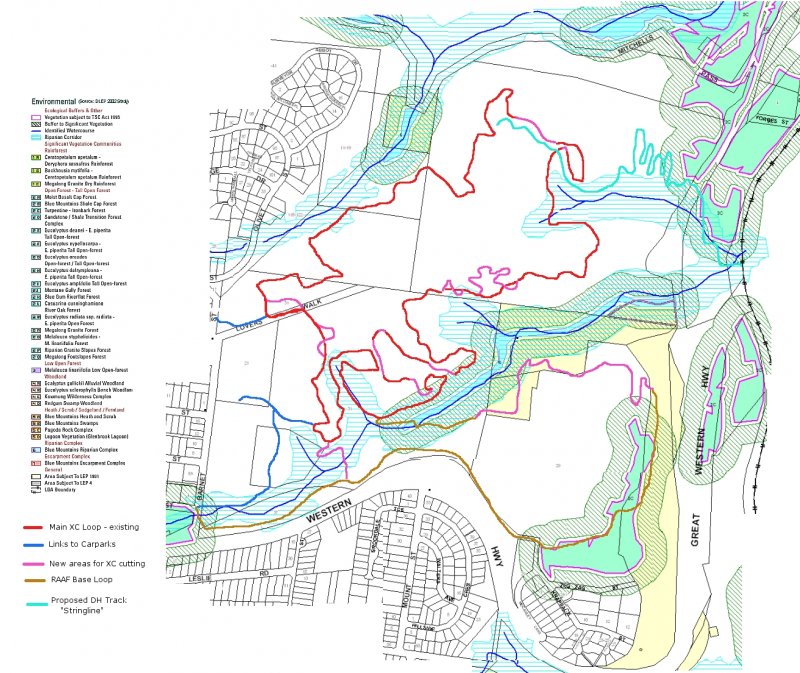
Main XC Loop
The main XC loop to be ridden in an anti-clockwise direction.
1) This would be the main "start point". Could be ridden in from the field or the skate park via the blue lines. These are firetrail or singe track. Parking at these places would minimise impact on local residents.
2) Fire trail descent.. slightly going to single track. Possibility to brushmat to single track?
3) Sort of singtrack descent
4) Ok single track leading down to the gully.
5) After crossing gully steep pinch. Very eroded and would need some work. Either a line change and close of the main erosion section with brushmatting and erosion prevention measures.
6) Uphill on ordinary wide single track.
7) Descend down some nice single track into the gully section. Possibility of line improvement.
9) Good single track after the gully. Climbs up with two pinches .
10) Winds up and around to use the small descent. Possibly request cutting some extra track (marked in yellow) to connect up with the existing single track.
11) Would be another small cut to get up to the "Two Logs" section.
12) "Two Logs" with possibility of a small cut to improve the corner in preparation for the fire road descent.
13) The fire road descent is tending towards becoming single track. Its a good fast waterbarred descent, but with brashmatting could have some curves put in to make it flow nicely.
14) Cut a small connecting track off the fireroad to the good singletrack that follows and loops around.
15) Very good section of single track.
16) Ordinary fire road. Needs a nice corner to connect 15 to 16.
17) Back on single track. At first gully crossing, very eroded, probably will need some switchbacks to change the gradient and a proper creek crossing.
18) Possibilty around this area to extend the track up into the bush... maybe??
19) Another very eroded section that will need to be adjusted for sustainabilty. Probably some switchbacks for climbs and descents.
20) Just more good singletrack
21) The section that crosses the DH track. Want to try and only cross this once for safety reasons. Some small cuts maybe in this area to allow for no doubling back. Ok wide single track, could easily be improved especially seeing it isn't really a walking track as it goes nowhere.
22) A parallel track up the hill that avoids the downhill track.
23) Would possibly join onto the firetrail while the DH track would be routed more interestingly in the scrub nearby.. keeping them seperate.
24) Wide single track
25) Firetrail that is growing over. Turning into single track. Flat and simple.
26) Messy technical fireroad descent. Top part could do with some erosion work. Probably make sure there was a super technical line with drops maintained as well as making sure there is a more intermediate rider line down as well.
27) Try and use the line that veers off to the right and then cuts back across the fireroad over onto the large flat rock. Just makes the descent a little more interesting and less an eroded fireroad.
28) Very boring firetrail
29) The Big Rock.. people can climb how they want. Work out and mark a more rideable transversing line up it as well for people wanting a nice continuous loop. The top part once again has considerable erosion on the fire trail. Possibilty to brushmat and make into singletrack??
30) Single track that needs some work to make it more interesting.
31) Drop onto a little bit of firetrail and then ride along the rock ridge.. nice that the bit of track is quite different in style.
32) Ride up narrow firetrail. Maybe cut a line here to minimise use of the "Lovers Walk" area but not really necessary.
32) Nice descent on old double track.
33) Really nice bowl shape to cut some nice switchbacks to reduce erosion. Vegetation is very much weeds and grass.
34) Old double track to keep away from the tracks at 5) near the gulley. Good climb.
35) Just some firetrail to finish the loop.
36) Access on firetrail and grassy single track to the carparks at the ovals (Unfortunately gates often locked) and the skate park area.
Need to workout total loop length.
"Stringline" Downhill track
37) Starts on the firetrail, but could possibly cut some extra length into a switchback or two to avoid the firetrail (which the XC would be using for a climb). Get some flow happening early on.
38) Possibly drop onto the fire trail for some of its waterbars and rock and cross the main "Lovers Walk". Visibilty is good for walkers and downhillers at this section which is the only critical area.
39) Crosses over XC track (need signposting on XC) and has a rock and root type section. This would probably be best to armour and make interesting rather than routing around.
40) Avoid an eroding section with some switchbacks which will add a little length and slow things down a bit.
41) At the spot where the track really becomes an eroded mess, head horizontally and then put in a switchback and head down at a lower gradient so as to not waste height. Nice and rocky.
42) Series of switchbacks to work oneself slowly down the hill not wasting height but providing technical features and nice corners.
43) Joins into an old trail for a short section.
44) Crosses the fireroad, under the power pole and then winds into the steep gully. Would need some building to get down and then some small woodwork to provide a ramp out onto the walkway using momentum from the proceeding section.
45) Possibility to use some of the old, half forgotten grown over firetrails to extend the descent.
Possible RAAF base loop.
This would be a way to extend the XC distance in the area. The main loop is an intermediate level track. This section would be a more advanced and technical track. Ridden clockwise.
46) The "Chute" would need a possible reroute at the top and then maybe breezblock armouring further down with a berm at the bottom to catch the riders momentum for the turn.
47) Technical river ride and crossing. Would need a better bridge. Steep descents and ascents. Maybe need some rerouting for the ascents.
48) Crossroads to the unlikely but worth investigating RAAF track.
49) Old track that rides around sewer works.
50) Possible climb that avoids the spooky "Deliverance" section of road. Cross over around sewer works and up the hill. Existing very steep fire trail but could cut some suitable climbing switchbacks to make it rideable.
51) Or alternatively through spooky bit along road and back around on the entrance track marked in blue.
This bit follows the fenceline around the RAAF base.. could be good but very unlikely it would ever be approved.
52) Good area to build a track through the rocks and vegetation.. bit winding and quite steep and technical. Great views.
53) Fenceline type track though grass.. not great. Also close to the RAAF living quarters. They may not like this.
54) Need a switchback or two to descend to the old station platform. Problem with the area in 52, 53 and 54 is there is a series of heritage controls over this area.
55) Climb up through old rail cutting.
56) Climb up.. could maybe get some nice switchbacks put in.
57) Return on some asphalt.
Nice work moggs.. I reckon a loop is much better idea too. (I get lost too easily ) apart from that it will be much easier to maintain and as you mentioned "sweeten" the trail. Apart from that avoid confusion and head ons.
Awesome work indeed Moggio, very professional. I agree with your principles of "loops". It will also make it easier for walkers to understand where the bike tracks are, and thus create less long term conflict.
I should do an Academy Awards speech here and say lots of people were involved in many capacities to work out these like Nerf, Kingy, Matt, Vinno and a big one for Chuck for drawing up all the strips of dirt randomly covering Knapsack in the first place to use as a basis for these maps and suggested trails. Lots of discussion and thought have gone into these from quite a few perspectives.
Still if people could wade through these and have a different opinion on anything that would be great... more perspectives the better!!
Please see below my comments on Moggios' good work. I have inserted the commetns one line below his, as I could not change the font to make it clearer.
Firstly, in my opinion having only one XC loop would be a retrograde step for local riders. The tracks from a rough “labyrinth” which means that you can ride trails of varied difficulty and character in a relatively small area. You can ride a steepish downhill going one way, which is a pinch climb the other. Some, however, are not rideable in one direction which is where the alternate loops come into play. To reduce this network to only one XC loop would take us backwards.
The main XC loop to be ridden in an anti-clockwise direction.
Agree that generally anti clockwise is best, but many of the sections are just as good, or better in the other direction.
1) This would be the main "start point". Could be ridden in from the field or the skate park via the blue lines. These are firetrail or singe track. Parking at these places would minimise impact on local residents. I think that the best start point should be right on the western end of lovers walk. This is the clearest location for anyone to find. The best way to get to point 1 on the map from the end of lovers walk is via a well formed slightly downhill single track on the southern side of lovers walk hooking up to point 36.
2) Fire trail descent.. slightly going to single track. Possibility to brushmat to single track?
3) Sort of singtrack descent
4) Ok single track leading down to the gully.
There are other options for points 3,4,5,34,35 which ad much more variety.
5) After crossing gully steep pinch. Very eroded and would need some work. Either a line change and close of the main erosion section with brushmatting and erosion prevention measures.
I would much prefer to retain two distinct lines in this section: one that links 4 to 8 directly and then onto 9, and the other 2 to 1 to 35 to5. They are very different rides and both should be retained.
6) Uphill on ordinary wide single track.
7) Descend down some nice single track into the gully section. Possibility of line improvement.
Gully section.. possibility of it being a sensitive area. However a good ride and some nice technical sections which would need some armoring. Also an important link to the chute if we are to try and include some of the RAAF base section (to be discussed from point 46 on).
Agree, the gully will need armouring if it is to be retained, which would be very preferable. The climb out towards the highway needs more switchbacks to be rideable for the vast majority of riders.
9) Good single track after the gully. Climbs up with two pinches .
10) Winds up and around to use the small descent. Possibly request cutting some extra track (marked in yellow) to connect up with the existing single track.
11) Would be another small cut to get up to the "Two Logs" section.
12) "Two Logs" with possibility of a small cut to improve the corner in preparation for the fire road descent.
13) The fire road descent is tending towards becoming single track. Its a good fast waterbarred descent, but with brashmatting could have some curves put in to make it flow nicely.
14) Cut a small connecting track off the fireroad to the good singletrack that follows and loops around.
15) Very good section of single track.
16) Ordinary fire road. Needs a nice corner to connect 15 to 16.
17) Back on single track. At first gully crossing, very eroded, probably will need some switchbacks to change the gradient and a proper creek crossing. I think that 16 to 19 should remain on the current alignment, but be armoured.
I just can’t see the benefit on making new track here.
18) Possibilty around this area to extend the track up into the bush... maybe??
19) Another very eroded section that will need to be adjusted for sustainabilty. Probably some switchbacks for climbs and descents.
20) Just more good singletrack. There is a really good steep chute just to the west that should also be retained.
21) The section that crosses the DH track. Want to try and only cross this once for safety reasons. Some small cuts maybe in this area to allow for no doubling back. Ok wide single track, could easily be improved especially seeing it isn't really a walking track as it goes nowhere.
22) A parallel track up the hill that avoids the downhill track.
The 22/23/24 as shown missed a nice technical section that forms a mini loop just to the north. The fact that this would make for a small figure of 8 doesn’t matter.
23) Would possibly join onto the firetrail while the DH track would be routed more interestingly in the scrub nearby.. keeping them separate.
24) Wide single track 24 to 29 has a much better alignment along the ridgetop as previously discussed; however the 26/27 line should also be left open.
25) Firetrail that is growing over. Turning into single track. Flat and simple.
The 25 section has several trails, some of which could be brushmatted and replaced with the ridge ride and one only single track. There would be a good sustainability advantage in this as a considerable area would be revegetated. It may be good to keep one narrow track here for beginners.
26) Messy (but fun) technical fireroad descent. Top part could do with some erosion work. Probably make sure there was a super technical line with drops maintained as well as making sure there is a more intermediate rider line down as well.
Agree; this is a good section and needs to be retained.
27) Try and use the line that veers off to the right and then cuts back across the fireroad over onto the large flat rock. Just makes the descent a little more interesting and less an eroded fireroad.
Agree to use the rock, but you can just aim left onto it at high speed, the first right as you have described it is not needed.
28) Very boring firetrail
29) The Big Rock.. people can climb how they want. Work out and mark a more rideable transversing line up it as well for people wanting a nice continuous loop. The top part once again has considerable erosion on the fire trail. Possibilty to brushmat and make into singletrack??
30) Single track that needs some work to make it more interesting.
31) Drop onto a little bit of firetrail and then ride along the rock ridge.. nice that the bit of track is quite different in style.
This is what I mean by the rock ridge along the top: some of it has the potential to be very good and with a distinct character.
32) Ride up narrow firetrail. Maybe cut a line here to minimise use of the "Lovers Walk" area but not really necessary.
32) Nice descent on old double track.
33) Really nice bowl shape to cut some nice switchbacks to reduce erosion. Vegetation is very much weeds and grass.
33 and 34 as marked is not the best spot to enter this area. The best takeout from the fire trail is about 80 metres west, and then onto he single track to the back of the oval.
34) Old double track to keep away from the tracks at 5) near the gulley. Good climb.
35) Just some firetrail to finish the loop.
36) Access on firetrail and grassy single track to the carparks at the ovals (Unfortunately gates often locked) and the skate park area.
Need to workout total loop length.
"Stringline" Downhill track
37) Starts on the firetrail, but could possibly cut some extra length into a switchback or two to avoid the firetrail (which the XC would be using for a climb). Get some flow happening early on.
I disagree with this option. There are big numbers of walkers through this area, including families with young un’s, older folk, pets and so on, and the track that is most travelled is lovers walk. All we need is one bad incident, and we risk losing the ability to ride the whole area. The crossover of a downhill and walking track is that incident, let alone an accident, waiting to happen. In my opinion the DH track should start on the east side of lovers walk.
38) Possibly drop onto the fire trail for some of its waterbars and rock and cross the main "Lovers Walk". Visibilty is good for walkers and downhillers at this section which is the only critical area.
39) Crosses over XC track (need signposting on XC) and has a rock and root type section. This would probably be best to armour and make interesting rather than routing around.
40) Avoid an eroding section with some switchbacks which will add a little length and slow things down a bit.
41) At the spot where the track really becomes an eroded mess, head horizontally and then put in a switchback and head down at a lower gradient so as to not waste height. Nice and rocky.
42) Series of switchbacks to work oneself slowly down the hill not wasting height but providing technical features and nice corners.
43) Joins into an old trail for a short section.
44) Crosses the fireroad, under the power pole and then winds into the steep gully. Would need some building to get down and then some small woodwork to provide a ramp out onto the walkway using momentum from the proceeding section.
45) Possibility to use some of the old, half forgotten grown over firetrails to extend the descent.
Possible RAAF base loop.
This would be a way to extend the XC distance in the area. The main loop is an intermediate level track. This section would be a more advanced and technical track. Ridden clockwise.
46) The "Chute" would need a possible reroute at the top and then maybe breezblock armouring further down with a berm at the bottom to catch the riders momentum for the turn.
47) Technical river ride and crossing. Would need a better bridge. Steep descents and ascents. Maybe need some rerouting for the ascents.
48) Crossroads to the unlikely but worth investigating RAAF track.
49) Old track that rides around sewer works.
50) Possible climb that avoids the spooky "Deliverance" section of road. Cross over around sewer works and up the hill. Existing very steep fire trail but could cut some suitable climbing switchbacks to make it rideable.
This would be very steep
51) Or alternatively through spooky bit along road and back around on the entrance track marked in blue.
I love the banjo
This bit follows the fenceline around the RAAF base..
could be good but very unlikely it would ever be approved.
52) Good area to build a track through the rocks and vegetation.. bit winding and quite steep and technical. Great views. It will be a struggle to get approval to build here (48-55)
53) Fenceline type track though grass.. not great. Also close to the RAAF living quarters. They may not like this.
54) Need a switchback or two to descend to the old station platform. Problem with the area in 52, 53 and 54 is there is a series of heritage controls over this area.
55) Climb up through old rail cutting.
56) Climb up.. could maybe get some nice switchbacks put in.
57) Return on some asphalt.
The route should be 49/57/ 56 then north along existing tracks down to 55, then down the switchbacks to a set of stairs leading to the highway's edge. You can then ride north to wherever you want to go. There is also a more direct r way down from 56 but it is quite steep, and used by walkers.
Great work to all those who have done the mapping thus far, it looks fantastic on the maps etc, and I agree with the idea of a XC loop for all the aforementioned reasons. Where the DH track crosses the XC track perhaps we can just zigzag the XC track so that XC riders have to slow right down before being able cross over the DH track, or build a bridge on the XC track over the DH track, saw something similar at the Nationals in Eildon Victoria. Having a bridge will avoid possible collisions and work within OH&S and IMBA principles.
Can't wait to see what comes out of it all, and to start creating tracks.
I don't agree with the upper section of the DH track as proposed. The reason is not due to potential collisions between riders, but collisions between a bike and a walker, of which there are plenty. In my opinion this risk is just too high, and the advantage to the DH track too limited.
Just my 2cents worth, others may well disagree.
Matt
Thanks for wading through everything and coming up with so many suggestions. Once again my comments below yours (we need a different font!!)
>Firstly, in my opinion having only one XC loop would be a retrograde step for local riders. The tracks from a rough “labyrinth” which means that you can ride trails of varied difficulty and character in a relatively small area. You can ride a steepish downhill going one way, which is a pinch climb the other. Some, however, are not rideable in one direction which is where the alternate loops come into play. To reduce this network to only one XC loop would take us backwards.
Few points here, this is being driven by council and what they want for the area which is a sustainable trail that works with the other users. A loop has been proposed by them to be able to control the area better. Coming from a point where all mountain biking was being deemed illegal on the escarpment and it looked like Knapsack would be lost we are now getting an option for a trail. They however want sustainable. Without this concept the POM could well have ended up being re-assessed and the area lost to legal mountain biking completely.
Council also seem to have a preference for single direction.
I think the concept of the area being a labyrinth really only applies to the area between the fields, and north of the gully where there is single track. (ie 1, 35, 8, 5, 6, 12 etc) The other areas link onto fire trails which will still be there, so the rest will be effectively unchanged. Rather than leave the area north of the gully as a tangled web, it was the opinion to maximise trail length and make this a good flowing section of single track. This is the area where there is the greatest likelihood of extending the trail with some nice trail sections.
Lastly remember basically under the guise of making this sustainable there is the option for making the track flow nicely like a mtb track should rather than just relying on luck to have a good section because that bit of erosion at this time happens to be kind of fun. Some of those currently dull sections and links can readily be spiced up.
So essentially the change is ideally to a place where there is trail designed for mountain biking taking advantage of every corner and surface irregularity to create a good mtb ride.
>Agree that generally anti clockwise is best, but many of the sections are just as good, or better in the other direction.
Yes, but with permission to build in the area, we hope depending on what council allows, to be able to adjust, reroute and design sections of track so that they do run nicely in the direction we want. Of course we don't know what council will allow..
> I think that the best start point should be right on the western end of lovers walk. This is the clearest location for anyone to find.
The thought was, still to be discussed with council, was to minimise the effect on the local residents. The carpark at the end of Lovers Walk is definately the most convenient but is near houses and has traffic of walkers. The rides in from the other areas is not overly far and if signposted would be straight forward. Still this is something council will be likely to have a definite opinion on.
>The best way to get to point 1 on the map from the end of lovers walk is via a well formed slightly downhill single track on the southern side of lovers walk hooking up to point 36.
Can you scribble this on a map?.. we didn't spot this one. We only knew of the firetrail below the number 32 that forks to 36 and 35.
The descent used at 33 we chose at this stage because it is a popular one for leading into the gully area, but also because there is a good likelihood to be able to build some extensions there to make a really nice descent. The bowl shape of the terrain and distressed bush there screams out for some nice winding corners... maybe bermed.
>There are other options for points 3,4,5,34,35 which ad much more variety.
Please definately sketch up all the variations you can think of and send them through.
At this stage this routing is basically just implying what we would like to do rather for the area rather than defining anything and setting it in stone. This routing was to create a loop that best used the current track features.
> I would much prefer to retain two distinct lines in this section: one that links 4 to 8 directly and then onto 9, and the other 2 to 1 to 35 to5. They are very different rides and both should be retained.
Remember the sections around 5 with the two gully crossings are not going to stay the same. If we are lucky council will let us use that area, which is already touch and go. If they do let us retain use of that area those crossings are so eroded and dodgy that a lot of work will have to be done to make them sustainable so the way they ride will be different anyway.
>Agree, the gully will need armouring if it is to be retained, which would be very preferable. The climb out towards the highway needs more switchbacks to be rideable for the vast majority of riders.
Yeah that section is tricky... not much room for switchbacks... have to see what can be done there. The gully to me defines Knapsack and most of the track runs really nicely and is sustainable, but there are those few iffy bits that need some improving.
>17) Back on single track. At first gully crossing, very eroded, probably will need some switchbacks to change the gradient and a proper creek crossing. I think that 16 to 19 should remain on the current alignment, but be armoured.
>I just can’t see the benefit on making new track here.
Because the descents are not sustainable. The options are to create some flowing switchbacks or armour the heck out of it. Or possibilty of armouring the descent and putting some kind of switchback in for the climb out on the northern side.
>22) A parallel track up the hill that avoids the downhill track.
>The 22/23/24 as shown missed a nice technical section that forms a mini loop just to the north. The fact that this would make for a small figure of 8 doesn’t matter.
Can you draw it on a map as well please?
>The 25 section has several trails, some of which could be brushmatted and replaced with the ridge ride and one only single track. There would be a good sustainability advantage in this as a considerable area would be revegetated. It may be good to keep one narrow track here for beginners.
Once again can you sketch those trails on a map.
We looked at the ridge track idea and in that area around 25 it seems like it would be very unlikely for council to approve that. Also it would require a considerable amount of work to create as it isn't really well defined and includes a large number of seperate rocks rather than large single rocks. A ridge track between 26 and 29 is more useful as it provides a separate line to the firetrail descent... some of it already exists, but yet again its a case of discussing with council and so far the reaction to the idea has been rather cold. The heritage issues as well with carvings and the like also raises potential problems.
> Agree to use the rock, but you can just aim left onto it at high speed, the first right as you have described it is not needed.
Its not needed but it is a flowyer line and removes even just 30 ft of fire trail which can only be a good thing. Again nothing set in stone.
> 33 and 34 as marked is not the best spot to enter this area. The best takeout from the fire trail is about 80 metres west, and then onto he single track to the back of the oval.
Discussed earlier... please mark on map... will go and look at.
> I disagree with this option. There are big numbers of walkers through this area, including families with young un’s, older folk, pets and so on, and the track that is most travelled is lovers walk. All we need is one bad incident, and we risk losing the ability to ride the whole area. The crossover of a downhill and walking track is that incident, let alone an accident, waiting to happen. In my opinion the DH track should start on the east side of lovers walk.
Downhill tracks do cross walking tracks in other legal riding places. The main trick will be putting a feature in before Lovers Walk that slows the riders down considerably and provides visibilty. The IMBA for these situations recommends two sweeping switchbacks which could only be a nice thing. This has been discussed with Soren as well and he didn't see it as being too much of a problem..
Also starting below Lovers Walk wastes around 12metres of height and 200m of distance. We don't have much to waste.
> 50) Possible climb that avoids the spooky "Deliverance" section of road. Cross over around sewer works and up the hill. Existing very steep fire trail but could cut some suitable climbing switchbacks to make it rideable.
> This would be very steep
Sure would... but some long switchbacks could be put in. Its unlikely due to the large amount of building but is worth parking the idea in councils minds for the future.
>51) Or alternatively through spooky bit along road and back around on the entrance track marked in blue.
> I love the banjo ?
What the hell is that place... freaked me out a bit. They do like Skim Milk there however.
> The route should be 49/57/ 56 then north along existing tracks down to 55, then down the switchbacks to a set of stairs leading to the highway's edge. You can then ride north to wherever you want to go. There is also a more direct r way down from 56 but it is quite steep, and used by walkers.
The tracks near the RAAF base are a real pain... they can be useful for access tracks to Knapsack but not much use for a ride within Knapsack. A line around the base could be done but is really unlikely due to zoning and I don't think the RAAF people would allow it. Would be a really great super technical track however. Require quite a bit of work too.
In some ways people can ride 46, 47, 48, 49, 51 if they want.. its contrived with the "Deliverance" section and road. Really council may close that section of anyway as it will be very hard to make it sustainable.... the chute down from 46 is a big enough problem in itself.
Just wondering seeing that Old Bathurst Road and Nichols were shut down and that Knapsack is the alternative site, potentially, what is the access going to be for DH, because at last look the gates at Knapsack have been shut for years and this then means that DH riders have to tolerate both a bit of a awkward shuttle route and they then have to pedal for ages to get to the start of the DH track. Or is there talk of the gates being re=opened?
Don't get me wrong I am very pleased with the possible options for XC at Knapsack but wonder how this will cater for DH, after all we lost not one track but about 4 at OBR alone, which is what started all this in the first place. And I am an avid supporter of all codes of MTB but want to make sure that DH is not just a side part to Knapsack reserve plans.
Also is there any potential to build all-mountain type tracks near Knapsack street area, as there were tracks cut in there years ago, albeit badly designed and maintained ones, but perhaps we ask for the most tracks and hopefully we will get some tracks.
The shuttle aspect for the DH is a bit of a dog. Sadly OBR was by far the best site for a DH track but due to a purely political decision has been shut down. Its suitabilty in all facets is what makes the decision so frustrating. However, yeah we have to live with what we got.
I really doubt that the gates would ever be opened at Knapsack. Its designated as another type of use area and the council and users like riders and walkers wouldn't want the potential for abuse by 4wds and well the stolen car brigade. It is a 1km ride from the drop off point, at least thankfully flat. But yeah.. very far from ideal!!
Really we are trying to make the best we can from the options with the downhill. If they let the new alignment through it will at least make the DH track very good from being rather poor oraverage as what is there currently. The man hours also to build it will vastly exceed the effort to be put into the XC work. It is the prime focus, the XC is a much more longterm, slower project that can be done little section by little section.
Of course all this planning is really window shopping, we don't hold the cards. Its all up to council to say what can be allowed. They may just balk at the whole thing for all we know and we are left with what is there now. And totally agreed we should ask for the most tracks or "options".
Probably worth asking for all mountain (or maybe it should be called "Expert XC" so that it can be bunched in with the XC allowed). Are you talking about the area at the bottom where there are the old forgotton jumps? If you want to draw up something on a map or write something up please do and email me mhawling@netspace.net.au.
I was thinking as well it might be worth suggesting a pump track as well down at the bottom too... nice flat area and unused.. pretty simple for something very cool.. and probably simple to get permission for.
Mog has address most aspects so my 10cents
A) Network versus loop
- To clarify the "Net work" or "Labyrinth" is really only in one section .. as highlighted by Mog above.
Network Advantage:
- adds diversity, by being able to ride a variant of the "loop" and therefore provides a perception of added length for those doing multiple laps or are frequent users.
- ability to ride certain sections in both directions, again adding diversity and seeming length.
- Ability to shut down sections for maintenance or rehab (however, realistically this has limited benefit here given the short spans that are added to make the maze).
- Presuming trail extensions are NOT allowed, then a network utilises the largest amount of track available.
Network disadvantage
- creates a labyrinth which is hard to follow, even with signage, and unsightly.
- sections become two way traffic increasing chance of collision.
- reduced track rationalisation benefits (which is a stated staff aim)
- reduces our ability to rationalise the sections which are less sustainable / less enjoyable to obtain additional sections of new track [1]
Loop advantage
- Clearly define one direction of the track to avoid collisions, increase speeds the track could be ridden, and allow walkers to clearly anticipate direction of cyclists on shared sections.
- assists with track definition and meetings rationalisation objectives.
- [WITH track extensions allowed] we can use track rationalisation as a compromise to obtain trail extensions to meet more sustainable targets, extend trail length, increase trail flow, all whilst linking the more interesting sections.
Loop Disadvantages
- Is hinged on obtaining approval to extend the track ... without trail extension and better use of the available terrain, maintenance efforts will be more frequent and intensive [2]. Further, without extensions we lose track length, where the current track length is relatively short already.
- Certain sections of track will be ridden in the "wrong" direction to what a number of local riders current do ... certain sections may also be closed / rationalised.
- The risk of riders making short cuts and re-establishing a network will be high unless, the loop is universally accepted.
To me, the loop has more significant advantages, like not having to worry about a head on, being able to push a section a little harder. However, it all hinges on being able to obtain trail extensions, which I believe is practical, given the type of vegetation we have sighted in the areas we think are best placed for redesign, and not loosing the best terrain aspects.
Like all things there will be compromise, however, I think a loop ticks more boxes for both riders, staff and other trail users.
[1] we haven't discussed whether trail extension is allowed yet ... however, it makes sense given Soren's use of "Corridors" and the areas we'd like to change are mainly grassy low significance areas.
[2]eg the junction near where sections 5, 8 and kinda 4 meet. you can see the downhill side of the gully is substantially more eroded then the uphill side, because water flashes down 3 track connections and the naural water course: note ... this is actually a network disadvantage too
B) Downhill connection to both XC and Fire trail.
- I agree, with the comments so far re the top of the track. I don't like how the DH and XC tracks are so close together, this is not ideal.
- Similarly, I don't like how the DH track crosses the main firetrail walk either.
We have a number of potential solutions here, mainly around redirection and trail extension, however, given the short amount of time available, I think we table what we have and discuss these issues in more detail as part of the design phase, which will likely be after the October report.
There is still a lot of negotiation, compromise, consultation and general discussion to be had so put this into perspective, when reviewing and providing your input.
C) Shared use tracks.
We haven't made any decisions re shared sections, bike only sections, or walkers only sections.
This is just a note for future consideration
I'm happy to lock this in to facilitate discussions with Soren and IMBA on the 16th and also with the view that there is still lots to do before we, lodge the assessment report, finalise design, and start digging
*edits ... made some spelzing changes and minor additions ... didn't catch them all though ... sorry english is not my first language
On the subject of the down hill crossing the fireroad there is no issue here, the visability is good we can create a reference to the code of conduct and we can put a pedestrian giveway sign for walkers this will an education thing, there would be more risk of some one hitting a pedstrian on a single track descent than this fireroad intersection, that aside as stated the compromise of losing that much altitude would be a very negative thing for the overall appeal of an ready compromised track site
I personally think that network is the way to go, a loop will limit things especially if down the track an area needs to be worked on you leave no where to go around, Soren likes theidea of a network he said so when we were at Knapsack, my thoughts are keep it as a network with flow in mind and a possibility of dual direction in different areas ( firetrail ) this will mean more diversity for riding
On the subject of the down hill crossing the fireroad there is no issue here, the visability is good we can create a reference to the code of conduct and we can put a pedestrian giveway sign for walkers this will an education thing, there would be more risk of some one hitting a pedstrian on a single track descent than this fireroad intersection, that aside as stated the compromise of losing that much altitude would be a very negative thing for the overall appeal of an ready compromised track site
We'll see re network ... whatever we can get at this stage.
I disagree with the walker education thing ... less impact on walkers the less likelihood of whinging. I think its in our interest to note the risks put up the alternatives (track redesign and new extensions) to mitigate the risk ... and leave it to Staff to make the decision.
The last thing we want is a collision, especially if we can mitigate it with relatively minor trail design changes.
Not withstanding, we'll see what we can get.
This has to be lodged tomorrow ... so please send your proposed changes / mark ups to Mog ... say prior to 2pm ... so he can lodge it with Soren along with data files before BMCC close of Business.
Remember there are other user groups too. Schools use it for Cross Country and Groups use it for Orienteering as well so single loop would affect what they do. If all tracks are mapped then we can discuss with Soren and as said previously we can then itemise what is bike what is dual use and what is walking only.
Without seeing the area I must say I like the idea of a network over a single loop as it gives less fit/beginner riders the option of a shorter loops and advanced riders the option of adding more techincal sections.
I also hate the idea of one way loops, traffic rules are for the city.
If it's a one way loop you need to cater for the beginner rider the whole way around as they don't have the option to cut off short and miss the harder bits.
Dangers of collisions is a perception thing as discused here
http://wiki.nswmtb.asn.au/index.php?title=User_C...
Our Gun Club DH track is popular with walkers, those who know it can attest to how narrow and confined sections are, an how much speed riders carry. It's been used for almost 20years now I I have never had a single report of a ride/walker collision.
Education is the way to go. If people are aware that other users may be on the trail coming in the other direction they will adjust their riding, awareness to suit.
It's only when people don't realise other users may be about and there is a chance that they may be heading int he other direction that they switch off and fail to keep an eye out.
Lidsdale has been open for 15 years, again we run races in either direction so people are use to riding in whatever direction and again not a single report of a collision or aggro caused by two way traffic
I think the term "network" here is confusing everyone. Networks like this
are awesome and attractive by the sound of it.
However what is sometimes being refered to as a "network" at Knapsack are several parallel sections that are maybe 100 feet long. Having a choice of riding either of the 100ft long sections that are really quite similiar is going to result in one being riden a lot (that is the one that rides slightly better) and one that gets ignored and gets grown over. However two 100ft long sections make 200ft of track and with a very short length of trail overall every section we can get is gold.
This is the area at Knapsack that is only around 300m wide so isn't really a network, just a tangled section of old trails.
There is enough room in the whole resrve at Knapsack to one day make a real network of trails, but obviously that would depned on council becoming very pro mountain bike trails which at the moment they aren't. Maybe in the future they can be won over.
The "network" idea that we are working with is having the main XC loop and secondary RAAF loop that is much more technical. The RAAF loop will also have the possibilty for exiting down to the zigzag and down to Emu Plains.
Within the main XC loop as it is crossed by a large number of fire trails there will obviously be many exit points and ways to repeat sections. The whole northern section will be able to be missed if one doesn't like hill climbing because there will be the main Lovers Walk fire trail down the centre.
However a defined loop so riders can come in and follow the arrows and enjoy a mountain bike trail that is designed with riding in mind is what is optimal. Currently Knapsack is not a good riding experience for someone who doesn't know their way around intimately.
If Knapsack can become a riding resource, say where riders can finish the Oaks, have lunch, spend some money and pop over for some more single track its only going to please the local chamber of commerce which is a bonus for justifying the whole idea of mtb tracks in the mountains in the first place.
Soren mentioned a one way approach, and in the end the trail is bound to run better one way than the other so its best we are prepared for that and have thought which way runs better in case we are limited officially. However we will argue for bidirectional, especially seeing it is not a particularly fast trail due to its technical nature and has very good visibility. Also due to ist length 4.9km at the moment using existing trails, making it bidirectional effectively makes it 10km of trail.
Fantastic work everyone, wish I could have been more involved.
Only have one suggestion for boring section 28. Cut it out. At the bottom of the firetrail (section 27) Switch back and ride down along the southern side of the creek to Lennox Bridge then cross over and ride back up the Northern side. Its different and adds some extra length to the track. Then join back in at section 29. There is also some unmapped single track on the northern side of the creek which could maybe also added.
http://bmorc.com/node/16442
for reference ...
How are we doing with finalising this mapping and report ?? would like to have it to Soren before Thursday where possible so he has a chance to look at it before Nic's site visit. I'd also like to have a read before we release it.
Let me know what I can do Mog
BTW
Rode awaba on the weekend ... if we want to press for a network I think we need to be pressing for more land. eg, otherside of Mitchell's pass ... towards the mushroom tunnel ... and dark common reserve.
I think we need higher expectations.
Oh emailed you Al about this, but in case you are ripping up the garden beds I will reply here too.
Working on it now. You will have something to look at tonight, maybe early text earlier, for sure as I have emailed my urgernt job I needed to finish for work. Will definately be out tomorrow morning. I just am really sick and hazy with fever so expect a few crazy bits.
Yeah Awaba is quite great in the scope of what they have pulled off on just a hillside with a few gullys to cross and nothing really flat. There are just no dead bits where you are just pedalling to get to the next good bit. Their usage of the terrain is so good.
I find the idea of the mushroom tunnel appealing in that council have the idea planted in their head now that more riding in that area could be a good thing. Really there is enough room neighbouring Knapsack to create a really terrif series of trails that could be shared by riders and walkers. I guess up to us to prove this first stage will be a valuable resource... and obviously if it can be shown to improve money in the local areas and the enviornment then the rest will follow.